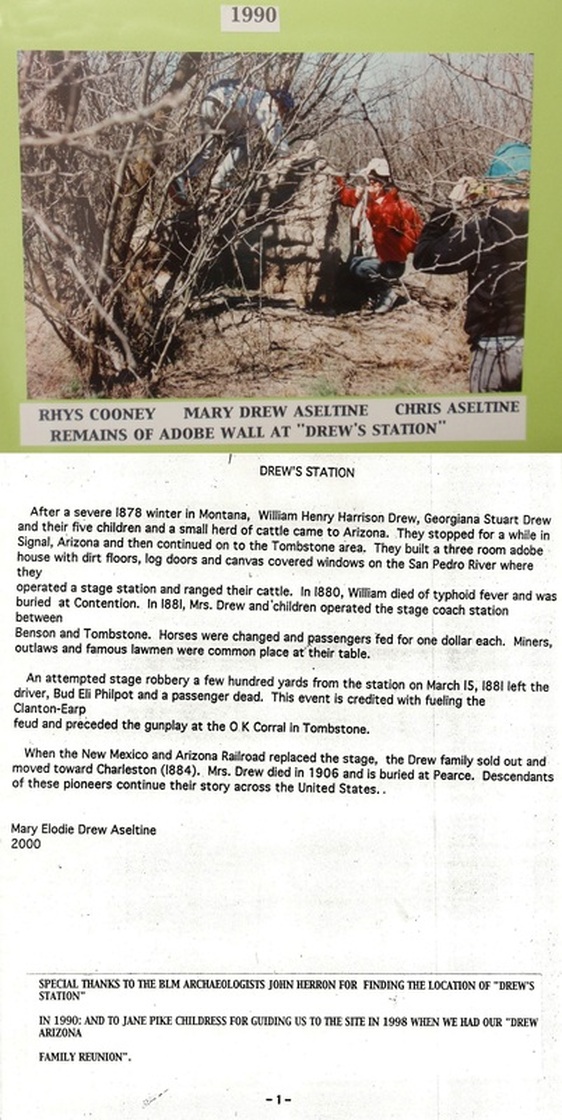
Drew's Station
Boyer or BLM??
Cora Drew lived here...or there
MARCH 15, 1881
ELI P. 'BUD' PHILPOTT AND PETER ROERIG
KILLED IN ROBBERY GONE BAD!!!
On March 15, 1881, the Kinnear and Company coach had passengers and Wells Fargo & Co.'s cargo on board. While traveling up an incline, approximately 200 yards this side of Drew's Station and about a mile the other side of Contention City * . . . A man stepped out and yelled, 'Hold!' Then a group of about eight men appeared. A shot, and then another, was heard coming from the same side of the road. 'Bud' Philpott, the driver, fell between the wheelers; he still had the reins in his hands. The horses ran wildly for almost a mile before they stopped. At this time it was realized that a passenger, Peter Roerig, had been mortally wounded.
It is believed that this was an attempted robbery of the Wells Fargo & Co.'s cache. Yet the robbers gained nothing by this murderous task.
* Reference: 'Tombstone Epitaph, March 16, 1881'
If the above, underlined, bold statement is true; then the robbery HAD to have taken place Between Contention City and Drew's Station.
A TALE OF TWO DREW'S STATIONS
Going to Drew's Station isn't as easy as you may think. First, you have to decide which one! May I suggest going to both? One Station was a Glenn Boyer find. The other has been called the TTR/Sosa site, but really is the old BLM site from some years back when BLM took descendants of the family to this site.
It would be nice to know which one was the site of the real Drew's Station, so you may want to do a little research on your own.
Why on your own? This is why......
The blog Tombstone History Discussion Forum 'TTR' at http://disc.yourwebapps.com/Indices/39627.html#143440 has been having a good debate for the most part...with the exception of one name-calling know-it-all who I refer to as 'Kokopelli,' as he is always blowing his own horn. Post, if you dare! I don't think anyone takes him seriously. But be warned. If you can read a map, you may be called a Luckless Butt-head. Most of the debate centers around which eye witness is the one to have the story correct. You could start with the little girl, Cora Drew, about nine years old at the time, and hang your hat with her recollection years after the fact. In this way, you will never have to get off your butt and really think about it...or do the math...or look at a map! Plus you save yourself from being hood-winked with the newfangled satellite imagery stuff! You just lie about the distance to the river from the site. Nobody really looks that hard to see if you're lying or just a Butt-head!
Seriously, in the time they spend with a back and forth, going nowhere, we could see both stations and a lot more!
If you are still wondering which site it is. Think about all the witnesses; all good people and just as poor at remembering what they saw as we are today. That's why this thing is going nowhere. The truth is in the distance from Drew's Station to the known site of Contention. The two Drew sites are almost a mile apart. So the real questions becomes, what is the mileage to Drew's Station from Contention?
Remember, two people lost their lives there in a botched stage hold-up that netted the robbers nothing. Everyone agrees it happened in a wash near the station so have a good look at each wash nearest the station at both sites.
**********************************************************************************************************************************
***********************************************************************************************************
MORE ON THE TWO DREW'S ! ! ! !
***********************************************************
Below are two Google Earth Maps showing the two sites. If you are following the story of the robbery, you'll remember the wash is BELOW Drew's Station. Some are confused by the use of 'BELOW;' they seem to think it changes with the direction traveled. Below IS always SOUTH !! South Carolina is below North Carolina regardless of your direction of travel. Same for the wash below Drew's Station. It is south of the Station or below the Station. You may wonder why this matters; both the BLM Site (that TTR and Nancy Sosa rediscovered) and the Boyer site have the robbery in the wash below the station. The point is that...
if they all agree on this...how could the robbery happen after changing horses at Drew's? The Stage was going north or up to Benson from Tombstone and entered the wash before it made Drew's Station no matter which one you think is the real Drew's. So to recap, unless you 'don't let the facts get in your way' or have a third site in mind, the robbery came before Drew's by 200 to 300 years.
Here's a link to one of the last posts on BJ's about Drew's station:
http://disc.yourwebapps.com/discussion.cgi?disc=39627;article=162846;title=B.J.%27s%20%20Tombstone%20History%20Discussion%20Form
The fact that Kokopelli has been M.I.A. from BJ's has made it a much better site.
Well I spoke too soon...Kokopelli is back just to tell us where he worked and to say anyone who thinks he's not right is a novice. He is also the first person who thinks a stage is part boat and travels the river. That's where he gets the up to Drew's Station from Benson, where the telegrams were received from. He's on the river, but not the stage, it's on the road. The road goes up to the north and down south. Better a novice than someone who has been at it a long time and can't follow map directions. I know trying almost anything to make the BLM site work is getting just a little nuts and you have to read this last one to believe it could go this far so here is the link to "UP THE RIVER." http://disc.yourwebapps.com/discussion.cgi?disc=39627;article=163471;title=B.J.%27s%20%20Tombstone%20History%20Discussion%20Form
You might be thinking by now why do I link you over to the Tombstone History Discussion Form if it's full of garbage like what's above...It's really not, there are some folks posting that know what they're talking about and can make a point so clear that they never have to go so low as to start name calling.
Here is just what I'm talking about and why BJ's is a good place for info if you just sort out the one or two Kokopelli
http://disc.yourwebapps.com/discussion.cgi?disc=39627;article=163487;title=B.J.%27s%20%20Tombstone%20History%20Discussion%20Form
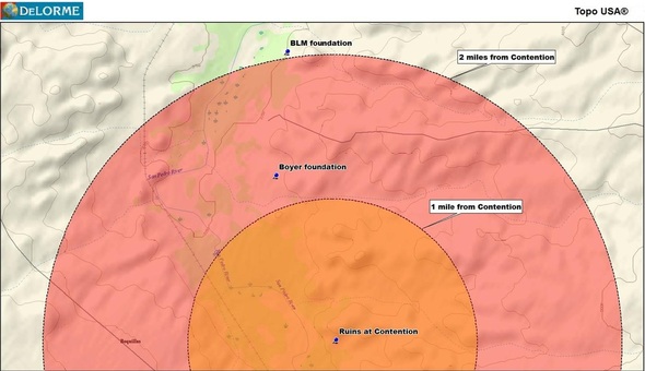
Still the one thing that matters most, is the distance from Contention City to Drew's Station. Keeping in mind that the two sites are almost a mile apart, this could be the one big difference between the two that tells the true story of the One True Drew's Station.
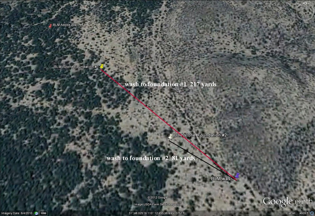
BLM site on Google earth
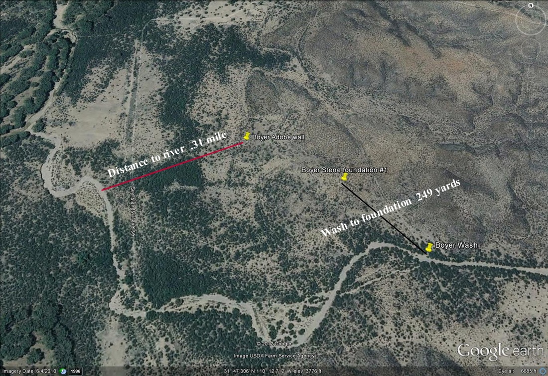
Boyer site on Google earth
Keeping in mind that the two sites are almost a mile apart...
about a mile the other side of Contention City.
Reference: 'Tombstone Epitaph, March 16, 1881'
'Approximately 200 yards this side of Drew's Station and about a mile the other side of Contention City.'
From telegrams received from Benson, at the Epitaph Office, the following particulars of the affair were gathered:
Note it says telegrams, not one, but 'more than one!'
'As the stage was going up a small incline, about two hundred yards this side of Drew's Station and about a mile the other side of Contention City, a man stepped into the road...'
The Epitaph Office is in Tombstone and the report is from that perspective. So, this side of Drew's Station is the Tombstone side. The other side of Contention City, is just that, the other side or the far side from Tombstone. Quick check of the map, if you really need it, and there it is, the robbery happened after Contention City but before Drew's Station. Next thing, there should be a wash 200 to 300 yards before Drew's Station. But there is more than one wash, pick the one about a mile the other side of Contention City. OMG !! There it is, a wash, with a foundation between 200 and 300 yards away, an adobe wall, and about a mile from Contention City (1.2 miles). This would be it, BUT Glenn Boyer found it first. Can't have that!!!
Another mile away (so over 2 miles from Contention City) is another wash and with a quick re-write we just go DOWN NORTH, circle the stage so it is UP SOUTH, and then the robbery happens after they change horses, but in the wash they went through before they got there.
Or, maybe, Boyer got this one right.
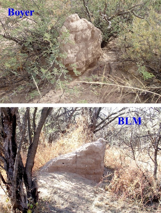
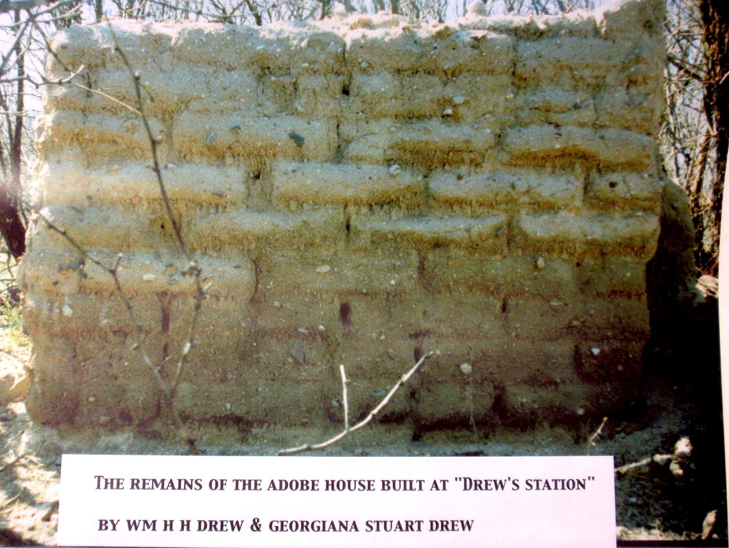
The three pictures below are courtesy of Sulphur Springs Historical Society
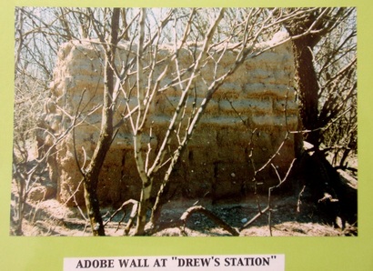
It seems apparent from the pictures that the adobe wall located at the BLM (Sosa/TTR) site is melting away fast. BLM’s Archaeologist, John Herron, found this location back in 1990 (22 years ago), and it was rediscovered a few years ago by Nancy Sosa. You can see how much the wall has weathered (see picture at top of page) in just those few years.
I’ve gone with the old Boyer site for a very simple reason, the BLM site only works if you change the facts as reported in the Tombstone Epitaph Newspaper. I believe people could and would get the facts wrong after many years and Cora Drew is a great example of this. But the report of the paper gives distances, by the people that lived there and traveled those roads in current time. We all know how far to the next small town or other places we go to often and so did they. What would be the chances that the report would fit so well with what we found on the ground. A mile the other side of Contention City and 200 to 300 yards this side of Drew’s Station. It’s there just as they reported. No need for a rewrite or making up things like (up south and down north).
I’ve gone with the old Boyer site for a very simple reason, the BLM site only works if you change the facts as reported in the Tombstone Epitaph Newspaper. I believe people could and would get the facts wrong after many years and Cora Drew is a great example of this. But the report of the paper gives distances, by the people that lived there and traveled those roads in current time. We all know how far to the next small town or other places we go to often and so did they. What would be the chances that the report would fit so well with what we found on the ground. A mile the other side of Contention City and 200 to 300 yards this side of Drew’s Station. It’s there just as they reported. No need for a rewrite or making up things like (up south and down north).
Personalities have trumped the facts in this discussion for the last few years. If Glenn Boyer finding this site is a major problem for you just lead with the…even a blind pig finds an acorn once in a while.
Not historically accurate ? Well that’s not Drew’s…so
If you made the trip to both sites and took along the story of the robbery, you already know what took 40 years to rediscover... Boyer was right. The BLM/Sosa site is wrong on many levels. Mostly location...well in fact that’s really it, isn’t it? But if you spent some time there, you had to notice the wash is wrong, you have to go out of your way to run through it because it’s too far east. Just walk up the road like you’re going to any one of the three ruins at that site and ask, how could anyone end up in that wash? Make sure you’re looking at the wash and not the ditch. The wash runs east and west and is southeast of the site while the ditch runs north and south and is east of the site. Stand in the wash at the spot in the picture from TTR, now look over to the ruins and you will have a “what the heck were they thinking moment”.
I believe Doug Hocking’s no nonsense posts on BJ’s Tombstone History Forum was the real driving force in bringing the site back to where it always was. His well-thought-out posts were hard, if not impossible, to dispute. His approach from the very beginning was the RIGHT SITE not the RIGHT PERSON.
The BLM site is there, along with another site just south of the Drew’s robbery location. There is a lot to research! With the Drew’s site back as an established mark, it's a good starting point.
For the people who want to see both sites, look at the Topo map and get some GPS coordinates. The following are the directions to both sites :
GETTING THERE:
Road into BLM parking/gate
Turn off route 80 between mile markers 309 and 310 and head south/west.
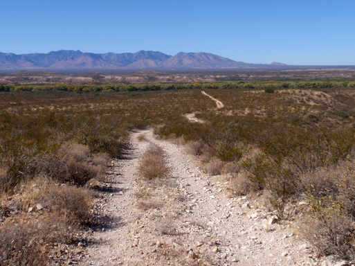
Stay on this road for 2.9 miles and you'll come to a BLM (Bureau of Lock Management) gate with lots of space to park. It's posted NO FIREARMS so practice your hiding skills. The Boyer site is off to the left and the BLM site is down the road and to the right. Neither is a bad hike but keep checking the GPS. There are many cow and human paths which we share, but remember the cows are not looking for Drew's Station and will lead you a-muck. Pick a path going the way you want , and off you go to Drew's or a water tank. Here's some GPS coordinates for both sites. Both have an adobe wall which would have been the house and a few stone foundations of other building plus the wash.
Boyer site GPS coordinates
Adobe wall N31 47.372 W110 12.755
Stone foundation N31 47.379 W110 12.755
Stone foundation N31 47.311 W110 12.618
Wash N31 47.215 W110 12.523
BLM site GPS coordinates
Adobe wall N31 48.096 W110 12.589
Stone foundation N31 48.056 W110 12.539
Stone foundation N31 48.004 W110 12.487
Wash N31 47.982 W110 12.448
